A key starting point for a Firewise effort is an evaluation or assessment of fire-related conditions in and adjacent to the community. The assessment basically takes a broad view of the overall situation, both positive and negative, and then identifies some possible improvement strategies. It brings together the insights of local fire professionals as well as affected property owners in a collaborative fashion. The Bailey Creek Firewise Assessment effort began in November 2014 with an inspection tour of the development. That then led to the preparation of a document that captured the reactions of the inspection team.
The Bailey Creek Firewise Assessment report contains considerable background information about the community and its setting. Starting with findings by the fire professionals regarding Bailey Creek fire hazard strengths and weaknesses, the primary factors can be summarized as follows:
Strengths:
• The community area features mostly gentle slopes and is not heavily
forested
• The structures are all built to contemporary building standards
• There are multiple ingress/egress routes on good roads
• There is a good water supply and fire hydrant system
• The development lies within a well-equipped and –staffed fire protection
district with a very favorable fire insurance rating (ISO 3)
Weaknesses:
- • Much of the surrounding area is heavily forested with dense stands
- • Heavy fuels exist in an area to the west that slopes down to the lake and that receives both afternoon sun and prevailing upslope winds
- • There is widespread and dense Manzanita growth within the development, especially on undeveloped parcels
- • Defensible space preparations on developed lots is inconsistent, suggesting a need for public education and encouragement
Plausible Fire Threats
A fire that begins within the development would be a significant concern to nearby homeowners, but the Firewise effort focuses primarily on fires that start external to the development. The assessment report notes that the fuels that exist in the surrounding areas could support a major blaze that could produce large numbers of airborne embers. Showers of such embers could quickly threaten large community areas a substantial distance from the actual wildland fire. This underscores the importance of creating and maintaining defensible space around all community structures, as well as reducing fuel loads within the community at large.
Some Recommended Actions
The assessment report points out the need for improvements in residential defensible space preparations through applicable techniques such as thinning crowded trees; removing the lower limbs of trees; removing brush and shrubs from beneath trees, decks or staircases; removing excess brush and shrubs; separating remaining vegetation; and reducing firewood stack hazards. Other recommendations deal with reducing home ignition hazards due to wood fencing or nearby shrubs, protecting propane tanks, and maintaining side and vertical clearance on driveways.
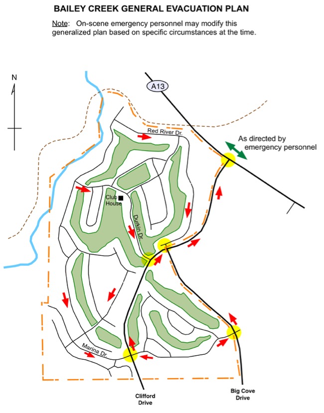
General Evacuation Plan
In the event of a significant emergency threatening the development the Plumas County Sheriff’s Office may issue evacuation orders. While it is impossible to illustrate evacuation routes for every conceivable situation, there is a need for a GENERAL evacuation plan that points out the most likely exit routes. That need has been satisfied in the assessment report with the diagram found below. It basically indicates that residents and visitors should take the most direct and safe route to Clifford Drive or Big Cove Drive and then proceed north to County Road A13, where emergency personnel will further direct evacuees.
The Complete Assessment Report
You can view the complete document by clicking on this link.