
Return to Faller page 2
Maps and
Locations.
(8/4/01) This map shows an area in Switzerland. Pink ovals are drawn around the region of Faller, the town of Mulegns, Bivio (the Roman Bivium), and the Septimer Pass (ref: House of Faller). The city of Chur (capital of Graubünden) is north of Mulegns, off the map. On the map is St. Moritz to the east. Directly south of Chur about 50 km, the road from Chur to St. Moritz turns abruptly east and meets the SS37 at the town of Silvaplana. The Julier Pass and Maloja Pass are on the main roads, and the Septimer Pass is presumably on a smaller road that cuts north from Maloja to Chur before reaching Silvaplana. Also note the Val Bercla and Val Gronda that meet at the top of the Val da Faller.
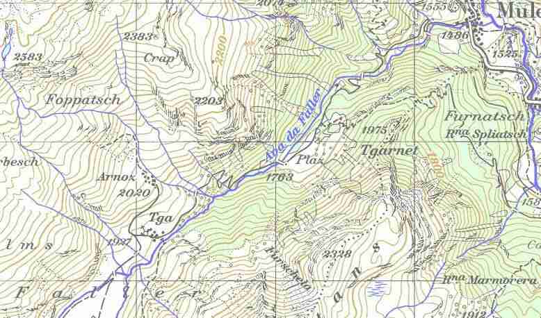
(10/30/04) This map shows the Val da Faller and Faller region in greater detail. (Thanks, Xaver Hutter.) Note the F A L L E R [region] spelled out near the bottom.
The following excerpt from "Geographisches Lexikon der Schweiz" was provided
by Robert de Falleur.
"FALLER, 1933 m., [is a] group of 12 huts,
inhabited in the summer, in the Val da Faller [Faller Valley], at the place
where the valley divides into two, at the northern foot of the Piz Platta and 4
km above Muhlen.
"FALLER, Val da: Romantic views of stony mountain tops, leads into Muehlen at 1460 m. Rises rather rapidly to the southwest and then extends up to a broad spread framed by high summits, in which Faller, inhabited in the summer, is situated. In the northwest, the powerful cliffs of the Piz Arblatsch and Piz Forbesch drop here to the Thal. In the south the Piz Platta separates the valley into two arms: to the west, Val Gronda, and to the south, Val Bercla, which are likewise both surrounded by high mountain summits. From the Val Gronda you reach the rarely scaled Thaelijoch (2802 m) at the Averser Weissberg, and beyond lies Avers Cresta. From the Val Bercla you reach the Fallerjoch (2770 m) and on to Juf in the highest section of the Avers. The Val da Faller is undisputedly one the greatest and at the same time loveliest landscapes in Graubünden. [My emphasis] Today it is a popular starting point for a whole set of summit routes, of which scaling the Piz Platta is called one of the most worthwhile."
The following snapshot of Ava da Faller was taken by Robert de Falleur during a recent holiday. Thanks for the photos, Robert.
(8/16/01)I've received an excerpt from Landnahmetätigkeit am Alpenkamm im Hoch- und Spätmittelalter from Robert de Falleur that has several pages (in German) on Val da Faller. Stay tuned for a translation sometime.
(10/30/04)This excerpt is from the on-line Historical Lexicon of Switzerland
(http://www.lexhist.ch/):
"Polit. Gem. GR, Kreis Surses, Bez. Albula. An der
Julierstrasse gelegenes Dorf am Eingang zum Seitental Val aller. Dt. Mühlen.
1850 120 Einw.; 1900 145; 1960 57; 1990 37. Im Val Faller wurde 600-500 v.Chr.
Kupfer abgebaut und eine Schmelze betrieben, ebenso bestand ein Erzbergwerk. M.
ist eine Gründung der Walser aus dem 15. Jh. (1521 urkundlich erw.). Diese
wanderten aus dem Val Faller ein, das sie ab 1200 besiedelt hatten. 1315 ist die
Alp Faller als bischöfl. Lehen erstmals belegt. Die spätma. Kirche St. Gaudenz
in M. wurde von den Kapuzinern 1643 durch die Barockkirche St. Franziskus
ersetzt. Bis in die Gegenwart haben Kapuziner die gemeinsame Pfarrstelle von M.
und Sur inne. In der Kapelle von Faller (Maria Heimsuchung und hl. Rochus)
befindet sich ein bemerkenswertes Altarbild von 1760. Im 19. Jh. wurden in M.
die Postpferde gewechselt (Ställe für bis zu 150 Pferde). Im Hotel Löwen stiegen
bedeutende Persönlichkeiten ab. Die Eröffnung der Albulabahn 1903 leitete die
Abwanderung ein. Gegenwärtig gibt es nur noch wenige Landwirte im Dorf. Die
Alpen im Val Faller - das im 18. Jh. verlassen wurde - sind verpachtet, die
Bergwiesen werden genutzt. Seit 1975 Primarschule mit Sur und Marmorera, seit
1963 Sekundarschule in Savognin. Seit 1994 Poststelle mit Sur."
A photo from Val da Faller (Faller Valley): 
A detail of the right front wall: 
Further excerpts from "Geographisches Lexikon der Schweiz":
"Fallera: (Kt. Graubünden, Bez. Glenner) Gem. u. Dorf. S.den Art. Fellers.
"Fallern: (Kt. Solothurn, Amtei Lebern, Gem. Ruettenen), 557 m. Group of 7 houses on southern foot of Weissenstein, on the popular footpath Solothurn-Fallern-Riesi-Nesselboden-Weissenstein."
(2/14/99) Simonswald to Eisenbach Map: Following is part of a map showing the features of the Schwarzwald around the Fallengrund (circled in the middle). Another Fallerhof is circled in the lower half. St. Peter and St. Märgen are also shown.

Fallerhofs can be found all over, near: Simonswald, Vörenbach, Urach, Breitnau, Langennordnach, St. Märgen, and Kappel, to name several.
(2/12/99) The following map shows the area around Gütenbach and Neukirch and some of the various farms mentioned in this site.
The farms in the Gütenbach area which are covered in the book by Klara Werber
are:
1. Obereckhof, 2. Untereckhof, 3. Ecklehof,
4. Kilpenhof, 5.
Kirnerhof, 6. Wolfetsgrundhof,
7. Bühlhof, 8. Oberlehmannsgrundhof, 9.
Unterlehmannsgrundhof,
10. Gutenhof, 11. Bachhof (Breiteckhof), 12.
Bachwirtshof-Vogtsgrund,
13. Unterscherenhof, 14. Oberscherenhof, 15.
Untergschwendhof,
16. Obergschwendhof, 17. Untergrundhof, 18. Obergrundhof,
19. Unterleimgrubenhof, 20. Oberleimgrubenhof, 21. Heiligenwaldhof.
The
number after "Gut." in the descendants file correspond to the chapter of the
book that includes the person.

Postcard photo of Gütenbach:
