SATELLITE VIEW OF WHAT'S LEFT
SATELLITE VIEW OF WHAT'S LEFT
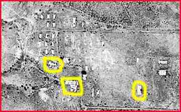
This is an old satellite photo of what is left of the camp. North is at the top. Circled from L-R, the chapel pad, mess hall pad and latrine pad. Above the chapel pad are several concrete foundations of the admin. area Quonset Huts. There were no pads or foundations beneath the Butler Buildings, but you can see where they were in the center of the photo. Down to the right are pads from the motor pool.
|
|
|
|