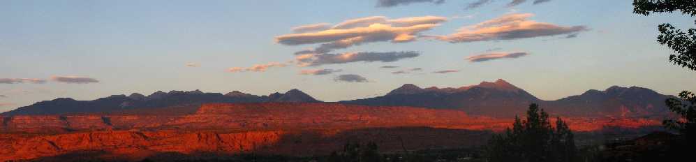
La Sal Mountains
- An Oasis in the Desert
Camping and
Travel Essentials for the
Manti-La Sal
National Forest
| La Sal Travel Maps | Ownership and Management | Nature and Cultural History | Recreation in the Natl Forest | Printable Brochure | Projects and Partners |
|---|
Mission of the US Forest Service:
“to sustain the health, diversity and productivity of the Nation’s forests and grasslands to meet the needs of present and future generations”
“It is not what we have that will make us a great nation, it is the way in which we use it!” Teddy Roosevelt, Our 26 th president. |

 The La Sal Mountains cross the Colorado-Utah boundary and include about 160,00 acres of public land managed by the US Forest Service and numerous private in-holdings, as well as two large parcels, totaling 28,500 acres, deeded to the State of Utah for its educational institutions. This checkerboard ownership causes challenges for management, law enforcement and recreational users, as there are over fifty access points to the National Forest and boundaries are not necessarily adequately signed. Limited resources for management of this District of the National Forest puts the onus on users to be familiar with and comply with regulations and to help the Forest Service meet its mission.
Current management of USFS land follows a 1986 Forest Plan, with some minor revisions. Dramatic changes in recreational use and development of nearby private lands and in-holdings, as well as a Federal Law, has required a completely revised Forest Plan to be developed, which is expected to be finalized in 2009.
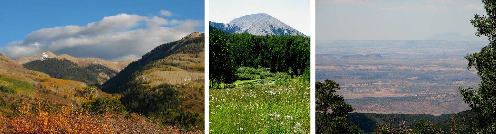
The towering peaks include the second highest peak in Utah, almost 9,000 feet above the Colorado River as it flows near Moab, a little over 20 miles away. Vegetation and wildlife communities contrast distinctly from those of the surrounding desert, with bear, elk and deer roaming pine, fir and aspen forests and vast areas above timberline of sensitive tundra.
After centuries of use by prehistoric and Ute people, and a few decades of excessive grazing, mining and timber harvesting by early white settlers, the remaining Federal land in the La Sals was set aside to strictly limit use of natural resources. The La Sal Forest Reserve, was created on January 25, 1906 by the proclamation of President Teddy Roosevelt. In 1908, two separate forested areas, the Abajos and Mantis were combined with the La Sals to be managed under one National Forest unit, the Manti-La Sal NF. Of the more than 1.4 million acres in this National Forest, the La Sals make up a little over ten percent (about 160,000 acres).
The Franciscan friars of the Dominguez- Escalante Expedition of 1776 were the first to record the name used by the local Utes, “Sierra de la Sal” because of salt flats nearby and where they gathered salt.
Geology:
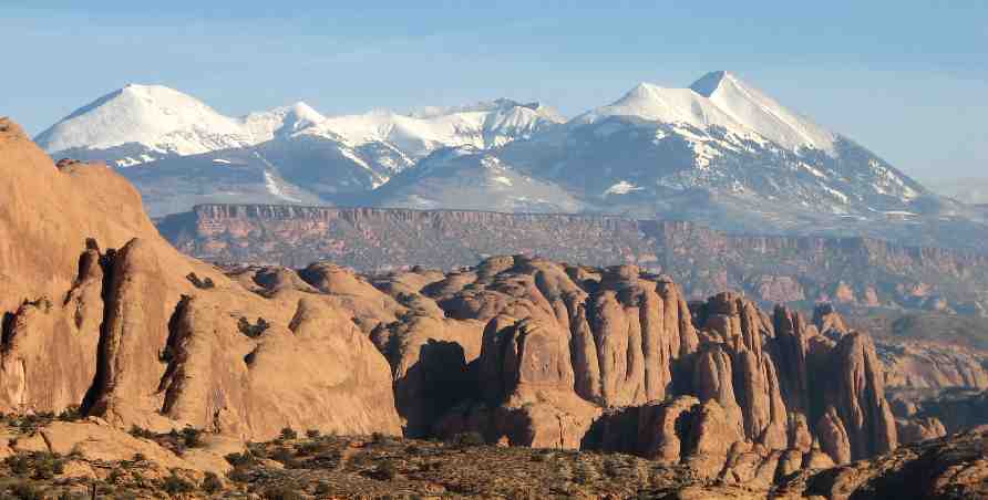
The La Sals are the erosional remnants of igneous intrusions termed “laccoliths” where molten rock from the Earth’s depths have bulged up pre-existing sedimentary layers like a blister, and oozed along weaker layers before solidifiying into hard rocks of granodiorite composition about 25 million years ago. Three pulses of intrusion gave rise to the three “massifs”, the northern and central masses being separated by Geyser Pass and the southern mass lying beyond La Sal Pass.
The northern cluster rose up along an extisting fracture in the Earth’s crust that aligns with the linear Paradox Valley to the SE and Salt Valley in Arches National Park to the NW. The largest of the three, this intrusive pulse left some concentrations of prized ore minerals, especially gold, that attracted miners to the area in the late 1800’s. Some copper migrated away from the intrusions, especially along the Lisbon Valley and Moab fault lines to leave deposits that are still mined today. Heat from the intrusions increased ground water circulation that most likely caused the migration and redeposition of uranium minerals in sedimentary layers surrounding the La Sals.
Successive ice ages, the most recent of which ended about 10,000 years ago, produced glaciers that shaped the mountains into what we see today. Outwash from the melting glaciers filled nearby Castle and Moab Valleys with boulders of the intrusive rocks that are the main sources of local building gravels.
Water and Soils:
 Snow melt and rain from the La Sals are the primary source of water for recharging springs and feeding perennial creeks in the surrounding desert. Several lakes, created by the Civilian Conservation Corps in the 1930’s offer additonal recreational opportunities. Unfortunately, earlier stocking of these waters with non-native Brook, Rainbow and Brown Trout by Utah Division of Wildlife has created competition for the native Colorado River Cutthroat Trout.
Relatively pure compared with mine-polluted creeks in the nearby Rocky Mountains, the greatest threats to water quality comes from siltation from nearby roads and route crossings and from trash and pollution from campers and other recreationists. Giardia, an intestinal parasite introduced from Asia in the last several decades, plagues all surface waters in the mountains and 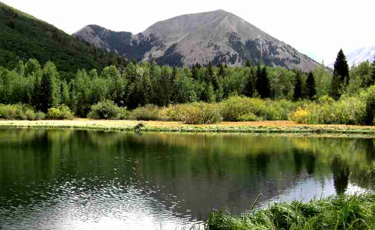 untreated water can be assumed to be unfit for drinking.
Soils are primarily derived from the bedrock and are dominated by sand and clay from the Morrison, Dakota and Mancos Formations. Clay soils are particularly prone to compaction by motorized vehicles, especially when wet. Such compaction can remain a significant barrier to plant growth and soaking in of snow melt and rain water for decades and causes increased run-off, faster moving water and erosion. Since these surface waters cannot replenish ground water, springs and creeks cannot produce as much water during drier periods.
Plants:
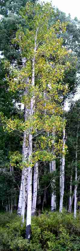 The La Sal Mountains are adorned by a rich array of vegetation that changes dramatically with elevation. Communities are divided into Pinyon-Juniper belt at the base, through Pine-Oak, Fir-Aspen, and Spruce-Fir belts as timberline is approached. Above timberline, low-growing grasses, sedges, stunted shrubs and wildflowers typify the Alpine zone. Surviving with a short growing season, this vegetation community is particularly susceptible to recreational damage. The La Sals are devoid of several confier species found in the nearby-by Rocky Mountains, including lodgepole, bristlecone and limber pines. As temperatures warmed following the last Ice Age, the different vegetation communities crept up the mountainsides to their current elevations, but migration of these pines was apparently inhibited by unfavorable clay soil barriers that surround the La Sals.
Firs are identified by their flat, flexible, blunt needles and cones that stand erect on branches. Spruces have sharp, round needles and cones that hang downward. Douglas Fir, abundant between the fir-aspen and pine-oak zones, is not a true fir and is easily identified by the cones, which have additional papery bracts protruding from between scales. Ponderosa Pine, which grows with Gambel Oak at slightly lower elevation, is recognized by needles that are typically 5-6” long, in bunches of 3. Less abundant on the west side of the La Sals, these trees can live to 500 years. The mountain islands of southeast Utah (La Sal, Abajo, Henry) contain 75% of all of Utah’s ponderosa forests. Berry-producing shrubs, including currant, raspberry, elderberry, chokecherry and snowberry are abundant in pine and aspen forests. Riparian and wetland areas dot the landscape with clear creeks, lakes and springs that feature water cress, water-birch, willow and stinging nettle.
Soil compaction severely interfers with water and nutrient flow for plant roots, killing trees and preventing regeneration of shrubs, grasses and wildflowers. Soil erosion, resulting increased runoff of surface water can also expose roots and kill trees or cause them to fall down. Disruption of rocks in shallow-soil areas by excessive travel can also increase erosion and destabilize trees.
The La Sals are somewhat isolated from encroaching non-native invasive plants because they are "Island Mountains". However, weed seeds introduced from elsewhere, on vehicle tires and camping equipment, are becoming an increasing threat to the health and enjoyment of the forest. Damaged areas laid bare of vegetation are particularly susceptible to invasion of weeds. In an attempt to reduce threat by invasive species, in 1995 the Forest Service introduced regulations requiring the use of only weed-free hay for domestic animals.
Wildlife:
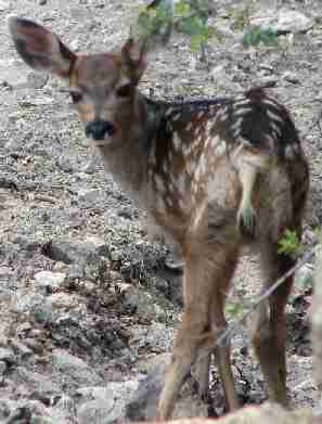 The La Sals support abundant populations of elk, mule deer, black bear, bobcats, cougars, coyotes and red and gray fox as well as numerous smaller animals. The desert surrounding the mountains has prevented migration of most species and those killed off by early settlers, such as Rocky Mountain Bighorn Sheep, Grizzly Bear, Gray wolf and lynx are unlikely to return without re-introduction. Management of game species is controlled by Utah Division of Wildlife Resources although monitoring of indicator species is conducted by the Forest Service.
The greatest threats to wildlife are habitat loss and overcrowding of remaining healthy habitat by displaced wildlife. Recreational use contributes to loss of habitat by fragmentation caused by roads and human presence, in addition to affects on soils, hydrology and weed invasion. The largest roadless area in the La Sals, excluding the peaks, is Gold Basin, nestled between peaks of the central massif.
Due to the limited income for forest management from valuable mineral, energy and timber resources in the La Sals compared with some other forests, more emphasis has been placed on recreation and grazing use of this forest. Recreational use has grown dramatically in recent years and is being heavily promoted in the nearby tourist town of Moab. Growth in nearby towns and development of in-holdings is presenting ever-increasing pressure on the forest lands. The agency is constantly pressured by competing user groups to open new trails and ssensitive areas and to relax regulations. However, the Forest Service is mandated to conserve resources for future generations and to limit impacts to the level at which the forest health can be sustained on all levels, including water quality, ecology and scenic value. Users must assume personal responsibility to help maintain these goals.
The above information should make it clear why the Forest Service has its regulations in place. A few guidelines for responsible and safe recreation are included on the following sections.
National Forests are National Treasures!

“ Unless we practice conservation, those who come after us will have to pay the price of misery, degradation and failure for the programs and prosperity of our day” Gifford Pincot, First Director of the U.S. Forest Service, 1905-1910 |
|---|
printable brochure p 1 (258kb) |
printable brochure p2 (351(kb) |
Recreation Tips for a Healthy Forest
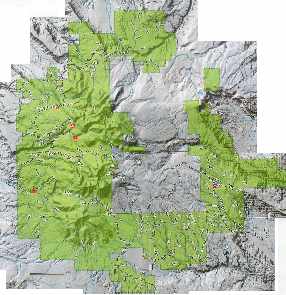
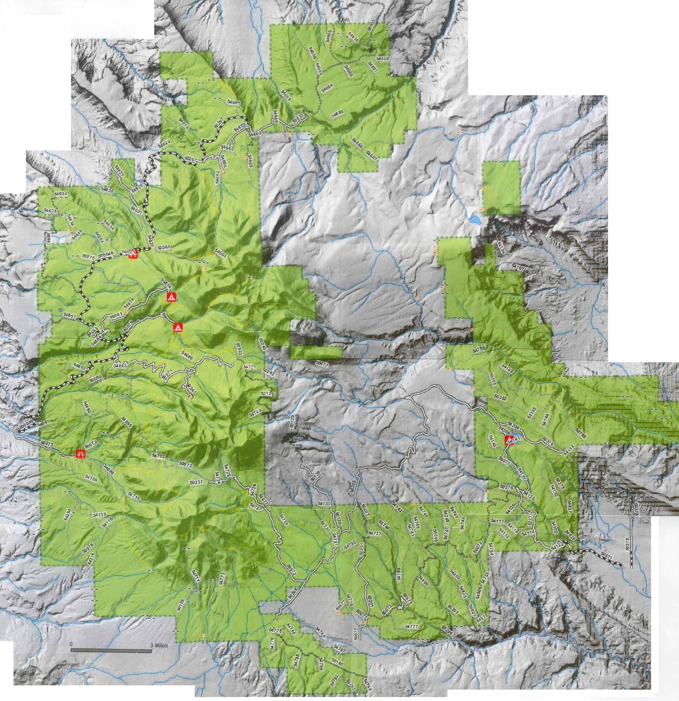
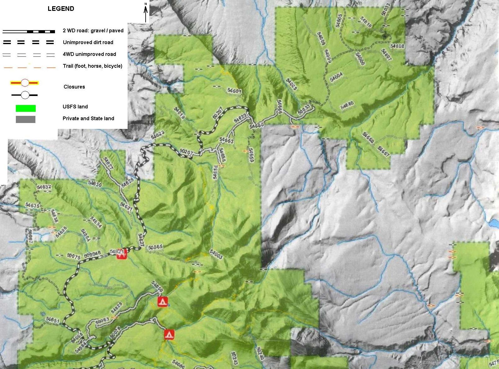
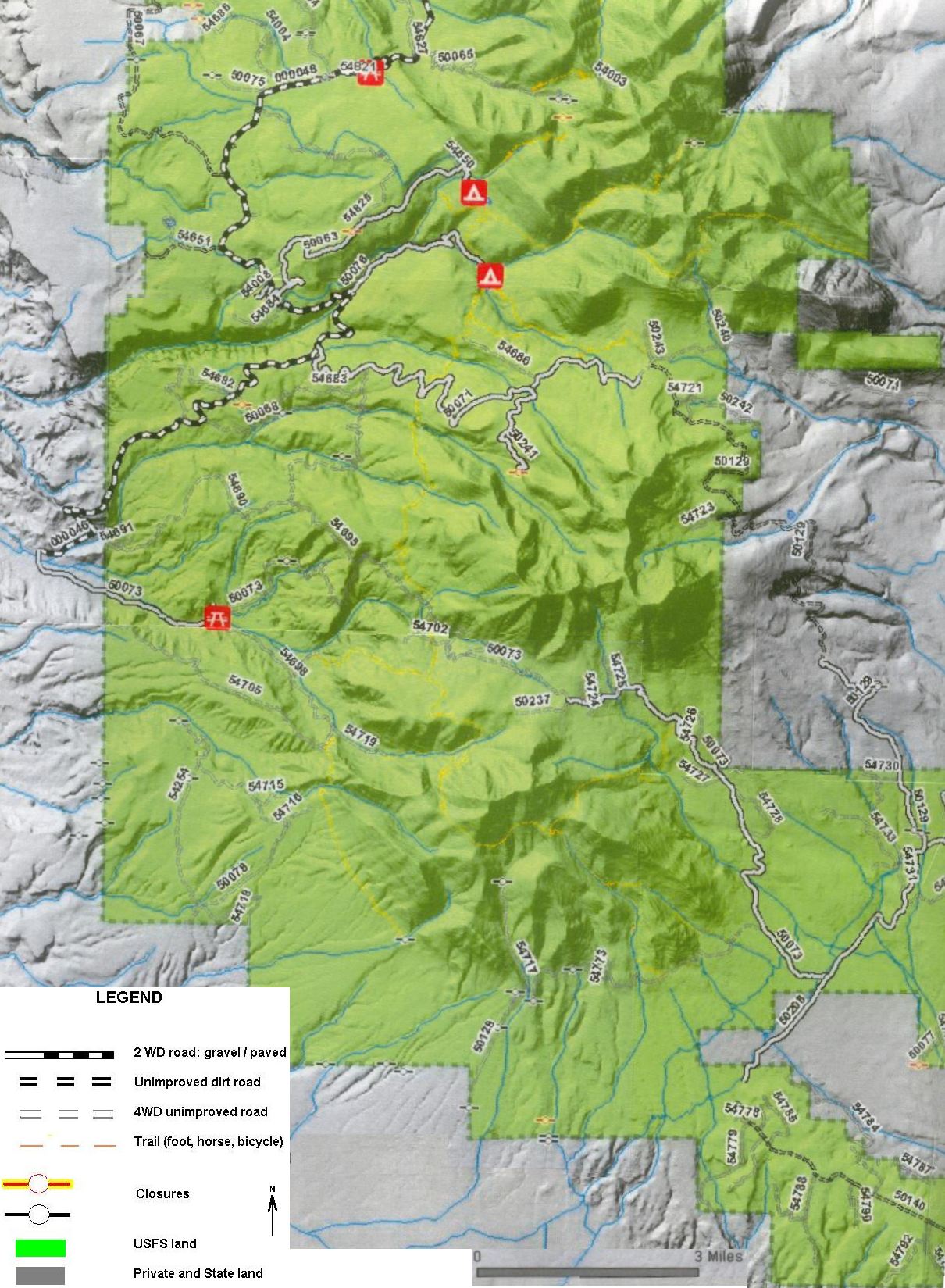
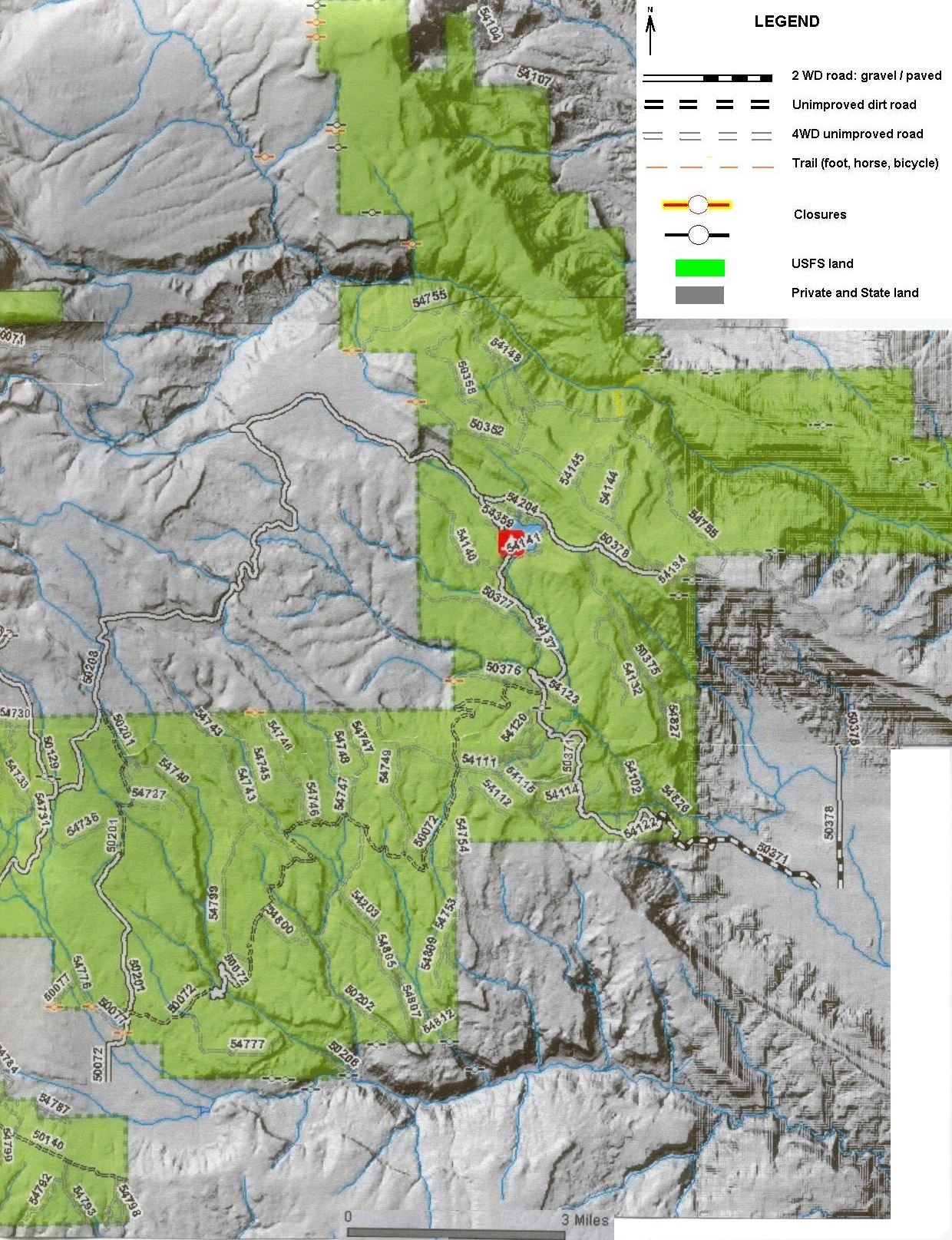
Approved travel routes Motorized and mechanized travel in most of the Manti-La Sal National Forest is restricted to approved routes. Travel Maps showing these routes can be obtained from the USFS or Moab Information Center. Even the most recent commercial maps contain many errors. The USFS is developing a new Forest Plan and will print a new map when the new management plan is finalized in 2009.
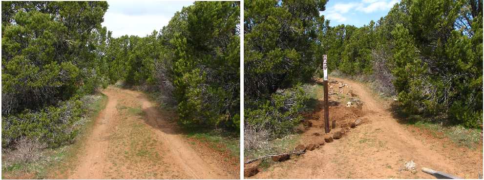
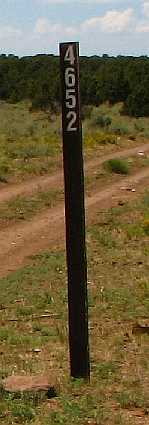
and also be viewed on the USFS interactive map site: http://maps.fs.fed.us/fp/r4/manti_fp/viewer.htm Maps from from this second site have been compiled and made available on-line below to provide you with a printable and viewable map without internet connection. These images are intended for education only and not for commercial use. Non-motorized bikes in the La Sals are restricted to roads and trails marked open for their use Horse-riding and hiking is unrestricted. Route numbers on maps or signs may show 3 to 5 numbers. The last three digits uniquely define a route. Graded roads are marked with a horizontal sign showing the route number. Vertical brown posts show approved routes for motorized and mechanized vehicles. Be aware that most of these are not maintained and may have sections unsuitable for full sized 4x4 vehicles. |
Essentials for Forest Health Water Quality: Snow melt and rain from the La Sals are the primary source of water for recharging springs and feeding perennial creeks in the surrounding desert. The greatest threats to water include siltation from nearby roads and route crossings and pollution from campers and other recreationists. Soil compaction and erosion: Soil compaction from vehicle use and camping can have impacts that last for decades or longer. Clay soils, common in the La Sals, are particularly prone to compaction, especially when wet. Compacted soils remain a significant barrier to plant growth and infiltration of snow melt and rain water and resulting increased run-off enhances erosion rates. Since these surface waters cannot replenish ground water, springs and creeks cannot produce as much water during drier periods. Soil compaction severely interferes with water and nutrient flow for plant roots, killing trees and preventing regeneration of shrubs, grasses and wildflowers. Soil erosion exposes roots and can kill trees or cause them to fall down. Disruption of rocks in shallow-soil areas by excessive travel can also increase erosion and destabilize trees. Invasive Species: The La Sals are somewhat isolated from encroaching non-native invasive plants. However, weed Wildlife Habitat: The greatest threats to wildlife are habitat loss and overcrowding of remaining healthy habitat by displaced wildlife. Recreational use contributes to loss of habitat by fragmentation caused by roads and human presence, in addition to affects on soils, hydrology and weed invasion. |
Travel Tips for Sensitive Landscapes
|
Camping Recommendations
Other regulations Abide by all state ATV, hunting, fishing and firearm discharge laws. Details are available on-line: |
|---|
|
Maps from the following the USFS interactive map site: http://maps.fs.fed.us/fp/r4/manti_fp/viewer.htm have been compiled and made available here to provide viewers with a convenient, printable and viewable map without internet connection. As JPG files, they can be enhanced as desired. These images are intended for education only and not for commercial use. |
| Whole map ( 1.09Mb) | La Sals -north ( 312kb) | La Sals -west ( 325kb) | La Sals -east ( 391kb) |
|---|
|
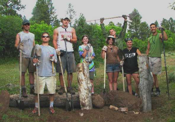
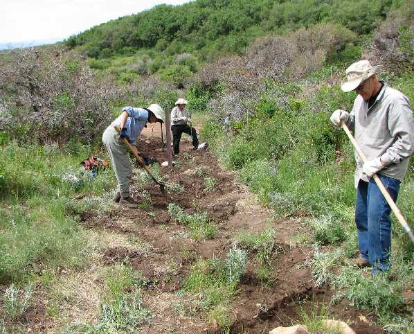
Plateau Restoration works closely with the USFS to ensure that projects are high priority with the agency and make conservation sense. Over 100 volunteers have helped the National Forest, under Plateau Restoration leadership in recent years. To find out more about how you can help, contact Plateau Restoration. Manti-La Sal NF Recreation Management We are conducting a project to help the Forest Service manage recreation through signing, monitoring, on-the-ground project work and educating the public through our service-learning programs and volunteer vacations. For more information clink on the above link. |
This website was produced by Plateau Restoration, Inc., a 501(c)3 non-profit organization since 1995. Please address inquiries to: Plateau Restoration Funding for the website and brochure was provided in part by a cost share grant from the National Forest Foundation (www.natlforests.org) and donations received for the Nature’s Legacy Fund managed by Plateau Restoration.
|
|---|
National Forests are National treasures!
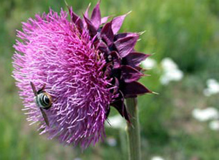 seeds introduced from elsewhere, on vehicle tires and camping equipment, are becoming an increasing threat to the health and enjoyment of the forest. Damaged areas laid bare of vegetation are particularly susceptible to invasion of weeds. The exotic invasives Musk Thistle (left) and Yellow-Star Thistle can render meadows impassable without being torn to shreds.