|
History Taylors Falls Local Events Activities Camp Store Reservations Package Deals Calender Map Home
|
Camp Waub-O-Jeeg | ||
 |
|||
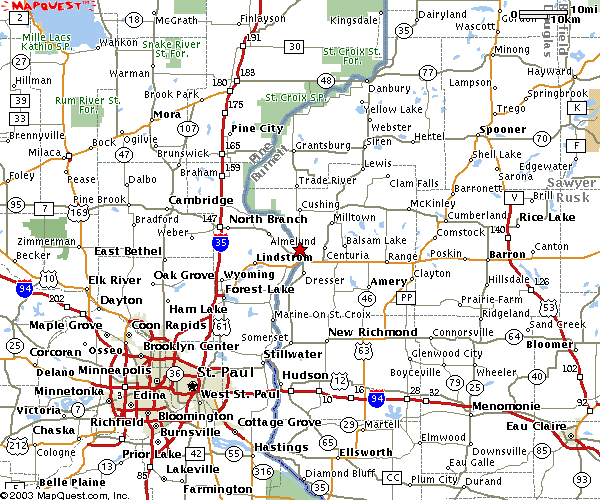
| FROM SOUTH Take 35W or 35E North just past Forest Lake to the Taylors Falls exit (Hwy 8). Follow Hwy. 8 20 miles to the stop light in Taylors Falls just before the bridge. Turn left at the light and follow Hwy 95 North four blocks through town to County Rd. 16 (Chisago Street). Turn right and follow County Rd. 16 along the river for 2 miles. The entrance to Camp Waub-O-Jeeg will be on your left. FROM NORTH Take 35W South to the Hwy. 95 (North Branch) exit. Follow Hwy. 95 East 20 miles to Taylors Falls. After coming down the bluff, just before entering downtown Taylors Falls turn left on County Rd. 16 (Chisago Street). Follow County Rd. 16 along the river for 2 miles. The entrance to Camp Waub-O-Jeeg will be on your left. FROM EAST Follow Hwy. 8 from Wisconsin across the St. Croix river bridge to the stop light in Taylors Falls. Turn right at the light and follow Hwy 95 North four blocks through town to County Rd. 16 (Chisago Street). Turn right and follow County Rd. 16 along the river for 2 miles. The entrance to Camp Waub-O-Jeeg will be on your left. FROM WEST Head East until you reach Highway 35 North. If south of Forest Lake, follow the directions above from the South. If North of North Branch, follow directions above from the North. QUESTIONS? Please call the campground at 651-465-3500 |
